Ali Bedni Bugyal Trek Map: Trail Breakdown and Campsites
- Jan 29
- 3 min read
Updated: Apr 27
Ali Bedni Bugyal is one of Uttarakhand’s most scenic meadow treks, famous for wide alpine grasslands and dramatic Himalayan views. A clear trek map helps trekkers understand the route, camps, and altitude changes before stepping into the mountains. This detailed guide explains the Ali Bedni Bugyal trek map, covering trail sections, campsites, terrain, and planning insights so you can trek confidently and safely.
What Is the Ali Bedni Bugyal Trek Map and Why It Matters
The Ali Bedni Bugyal trek map outlines the complete trail from the base village to the high-altitude meadows. It highlights campsites, water sources, forest sections, and ridge walks. Using a proper map helps trekkers:
Understand daily distances and elevation gain
Identify safe campsites
Prepare mentally for steep or exposed sections
What Is the Complete Ali Bedni Bugyal Trek Route Overview
The trek usually starts from Lohajung village and moves through forests, clearings, and vast meadows before returning via Wan or the same route. Key route highlights include dense oak and rhododendron forests, Ali Bugyal’s endless green expanse, and Bedni Bugyal with panoramic mountain views. The total trek duration ranges between 5 to 6 days. To understand why this experience is unique, see why trekking in India beats typical holidays.
What Are the Base Village and Starting Point on the Trek Map
Lohajung Village as the Trek Base
Lohajung sits at around 7,600 ft and serves as the main base camp. Important features marked on the map include road access from Rishikesh, accommodation clusters, and medical points. Interestingly, Lohajung, Uttarakhand also acts as a hub for the famous Roopkund trek and Brahmatal treks.
What Does the Day-Wise Trail Breakdown Look Like on the Map
Lohajung to Didina or Wan Trail Section
The first day involves a gradual ascent through villages and forests. The altitude gain is moderate and the trail is well-defined. This section helps trekkers ease into the trail comfortably.
Didina or Wan to Ali Bugyal Section
This stretch shows a sharper climb on the map. Forests slowly open into meadows, and Ali Bugyal eventually appears as a wide plateau. You can read more about why this is the most beautiful meadow trek in the region.
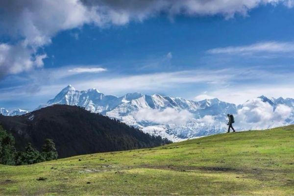
Ali Bugyal to Bedni Bugyal Section
This is the most iconic part of the route. It involves a gentle meadow walk with minimal ascent and continuous Himalayan views. The map highlights this as a long but comfortable walking day.
What Are the Major Campsites Marked on the Ali Bedni Bugyal Trek Map
Didina or Wan Campsite Details
These are lower altitude camps near local villages, making them good acclimatization points.
Ali Bugyal Campsite Location
Set directly on alpine meadows, these camps offer stunning sunrise views but can have cold nights.
Bedni Bugyal Campsite Significance
Bedni Bugyal is the highlight campsite, featuring the famous Bedni Kund and views of Trishul. For those planning their finances, here is a guide on budgeting for Ali Bedni.
What Altitude Profile and Gradient Does the Trek Map Show
The map shows a gradual altitude gain:
Lohajung: ~7,600 ft
Ali Bugyal: ~11,500 ft
Bedni Bugyal: ~12,500 ft
The steady ascent reduces the risk of Acute Mountain Sickness. Be sure to follow the AMS rules for high altitude to stay safe.
What Terrain Types Are Highlighted on the Trek Map
Marked areas include oak and rhododendron forest sections that dominate the lower half. As you climb, the map shows open ridge walking sections. Before you head out, ensure you have the right backpack for trekking to handle the varied terrain.
What Water Sources and Safety Points Are Marked on the Map
The map highlights natural streams and seasonal water points. It also marks forest check posts and camping restrictions. Understanding these points is part of a practical guide to Leave No Trace trekking.
What Seasonal Changes Affect the Ali Bedni Bugyal Trek Map
In summer, the map remains fully accessible with blooming meadows. However, during the cold months, the trail transforms into a Winter Wonderland, where snow covers large sections and requires experienced navigation.
What Navigation Tips Help Use the Trek Map Effectively
Always cross-check the map with GPS.
Start early to avoid afternoon weather changes.
Read the ultimate Himalayan trekking guide for expert navigation tips.
FAQ
What is the total distance? The complete route covers approximately 30 to 35 kilometers.
What is the highest point? Bedni Bugyal at around 12,500 feet.
Are there nearby trails? Yes, there are several nearby treks to do after completing this one.

Comments